The AeroRegis Platform

The operating system
for urban air
mobility.

AeroRegis is not a fleet management tool. It is not adapted from legacy ATC software. It is purpose-built, critical infrastructure — the unified operational layer that sits between the aircraft and the city, connecting every stakeholder in the ecosystem simultaneously.

Connected to
Aircraft &
Operators
eVTOLDronesHelicoptersFleet Ops
The Unified Layer
AeroRegis
Urban Air Mobility Infrastructure
Connected to
Cities &
Regulators
City GovFAA / EASAVertiportsATC
Unified Operational Visibility

Real-time visualization of aircraft, active routes, airspace constraints, and weather — shared simultaneously across pilots, controllers, and fleet operators. One common operating picture.

AURA: AI Deconfliction

The Autonomous Urban Routing Assistant detects conflicts 30–90 seconds before human perception. Real-time route deconfliction, predictive congestion modeling, automated flight plan validation.

4D Intent Enforcement

Every flight submits a route + altitude + time profile. Moving from hope to enforcement. Intent, Validation, Approval, Conformance, Deconfliction. Systemic safety before a propeller spins.

Coordinated Flight Management

Digital flight request, review, and approval workflows replacing manual voice communications. Dynamic routing and automated re-routing based on real-time operational conditions.

Human-in-the-Loop Authority

Augmentation, not replacement. Smart alerting eliminates alarm fatigue. Human decision-makers retain full authority, equipped with the complete situational picture to act decisively.

Audit Trail & Regulatory Alignment

Immutable logging of all flight authorizations and airspace changes. Built-in FAA/EASA workflow alignment from the ground up. Every operation is audit-ready automatically.

The command center
for every flight in the corridor.

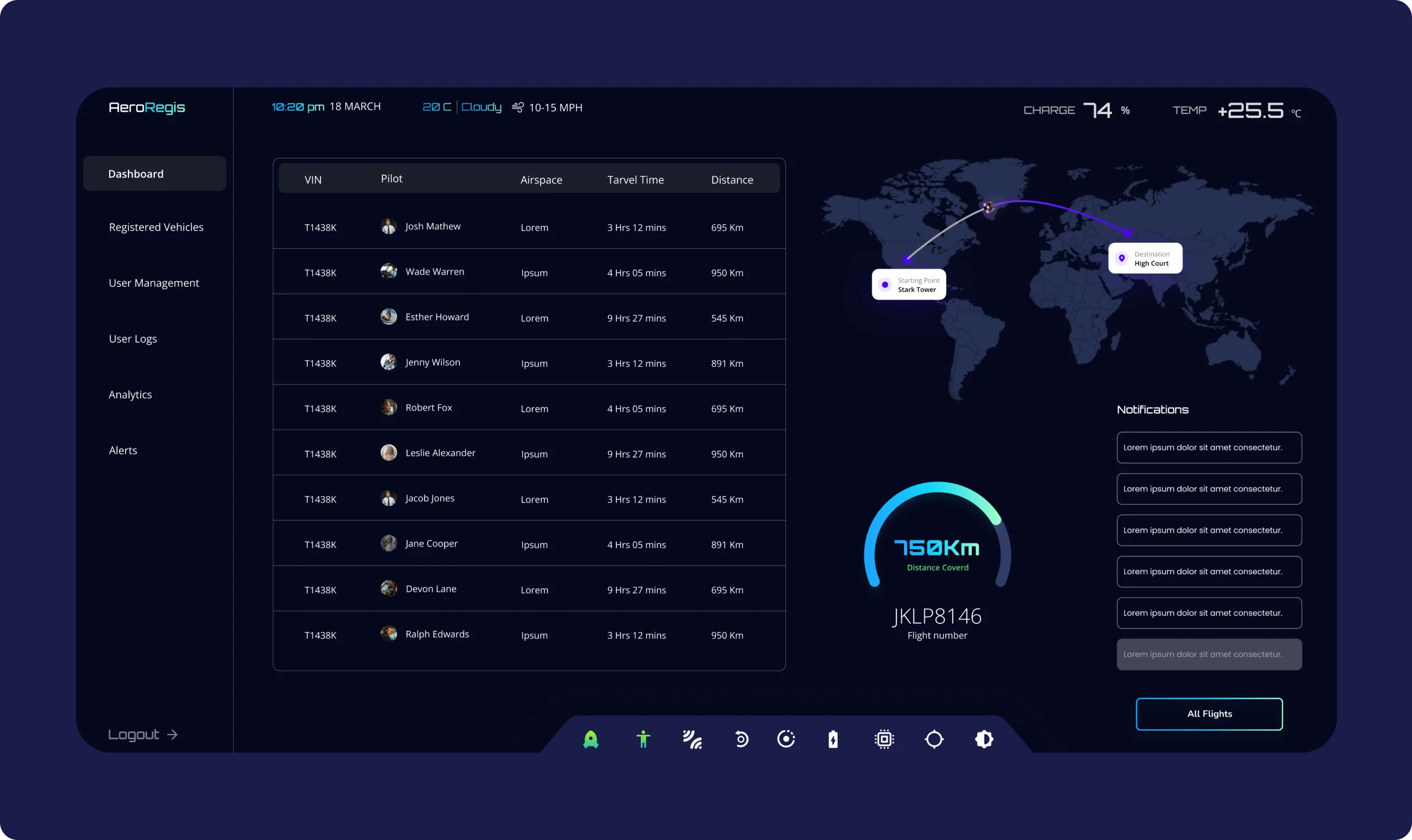
The AeroRegis operations dashboard gives controllers and fleet operators a unified real-time view — active vehicles, pilot assignments, airspace designations, travel time, distance covered, and live route visualization. Every stakeholder sees the same picture. No blind spots.

Operations Dashboard
AeroRegis operations dashboard — live flight table, route visualization, telemetry

Live flight table  —  Route visualization  —  Real-time vehicle telemetry

30–90s Earlier conflict detection vs human perception
100% Audit trail on every flight authorization
Vehicle Telemetry View
AeroRegis vehicle telemetry dashboard — altitude, speed, charge and route data

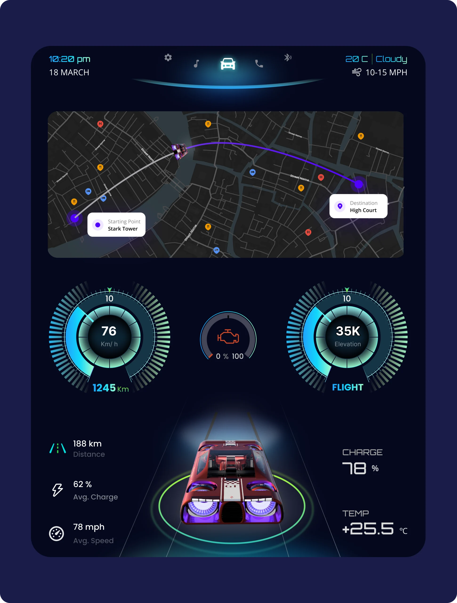
Altitude  —  Speed  —  Charge state  —  Route progress

Unified Flight Table

Every active vehicle, pilot, airspace designation, travel time, and distance — live. One view, all operators.

Live Route Map

Real-time corridor visualization with origin-to-destination tracking. Conflicts surface before they develop.

Vehicle Telemetry

Distance covered, charge state, flight number, and environmental conditions at a glance.

Command Notification Stream

Priority-ranked alerts and operational notifications surfaced in real time. Human authority, perfectly informed.